David explained that what London needs to do now is exactly what the city has needed to do for the last 42 years, that is:
"Quietly get on with building a high quality grid of cycling routes
to every destination and which absolutely everyone can use."
David also managed a dig at the National Cycle Network. This seemed somewhat odd to me. Last year almost five million people used this network. Yes, there is a long way to go still, but finding the faults in a network which is being developed by a charity and which is 22,500 km long does not require much in the way of genius, and ought to be beneath someone of David's stature.
The NCN was launched twenty years ago. The SCN (London Cycling Campaign's plans for a strategic cycling network) was launched thirty-seven years ago. I wonder how that's going?
On the very same day that TfL published their plans for the North-South and East-West cycle superhighways, LCC described them "a success" and "a major step forward". Their "main concerns" were that some of the planned new junctions were "not safe enough" and that the width of the new cycle tracks was "too narrow in places". Overall, however, LCC were "really pleased" by the commitment to convert motor vehicle space into cycle space.
LCC regarded the conversion of one of the slip roads at Blackfriars Junction to a two-way cycle-only route as "a great feature". They thought it "the iconic location for the transformation of London into a city with real space for cycling". Clearly, however, they haven't stopped to think how this scheme would fit into the bigger picture.
 |
| David Hembrow writes: "This proposal was praised in some quarters as at least including some segregation of modes. What it actually demonstrates is that the designers don't understand that bicycles are not the same as cars." |
I am particularly curious to understand why cyclists would go down the slip-road and then double-back on themselves in order to head east (at least two cyclists are in the process of doing this in the publicity shot above). Where have they come from, and where are they going to?

| 
|
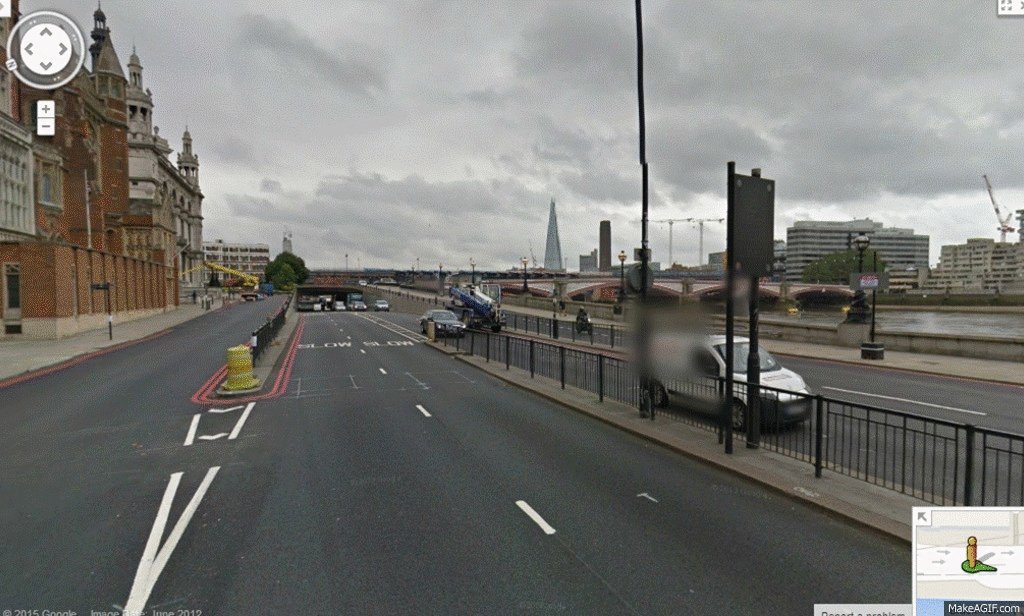
The map above shows what is probably the best route for motor traffic between King's Cross and Parliament Square. The photo shows the approach (from the north) to the soon-to-be-converted slip road, with the bridge straight ahead..

| 
|
The map above shows some of the main motor vehicle movements through Blackfriars Junction. Motorists wishing to travel to Parliament Square from the City, say, are enabled to avoid Blackfriars Junction altogether and get on to Victoria Embankment via White Lion Hill (pale red-coloured route).
Anyone wishing to travel to Parliament Square from pretty much anywhere south of the river could actually afford to give Blackfriars Junction a fairly wide berth. Indeed, very, very little traffic would cross Blackfriars Bridge south to north and then head west on Victoria Embankment. As the photo above right shows, most of the traffic goes straight on through this junction (from the south).


In the case of the route described above, the more direct route would reduce the journey distance by (only) 28%.
The new East-West route from Blackfriars Junction to Southwark Bridge (selected images)
Another thing to bring to your attention is that the section of route between Blackfriars Bridge and Southwark Bridge is not a destination in and of itself (there are no shops, for example). The point being that most of the people who travel along here want to be somewhere else. As the animation sequence shows, the only place that pedestrians are visible in any numbers is at Southwark Bridge.
Of course, there needs to be a way to connect the North-South route with the East-West route, and that slip road is probably the most suitable. But the new road layout would almost certainly better serve the needs of cyclists if it wasn't so massively over-engineered. (Since also one of the lanes on the slip road is pretty much entirely superfluous, why not plant a few trees there as well?)
I have no doubt that when these superhighways come to be built, a lot of kudos will go to Boris Johnson and TfL. But these schemes fall short in my opinion because they don't form part of a bigger whole.
The most effective way to develop an amenable cycling environment is to plan, study and then introduce a network—get it up and running—and thereafter to develop it further on the basis of priority interventions and a timetable. That's what the Dutch started doing in 1973, which means that this, therefore, is the true meaning of Going Dutch.
It seems obvious to me that the Cycle Superhighways are often going where they can be installed without causing too many problems, rather than where they would be most useful.

| 
|
Why, for example, does the recently-announced CS1 replicate the old LCN10 almost exactly (except for the bits in red) when it was originally proposed to be routed along the main road? Improving the functionality of a couple of the crossings is well and good, but cycling needs density and connectivity, and despite its faults, the old LCN route at least had the advantage that it joined up to other routes (notably CS7). How is CS1 going to fit in with everything else?
Why, as well, does the new North-South route go from Elephant and Castle to King's Cross, rather than, say, from Elephant and Castle to Finsbury Park? It would mean that the North-South route on Farringdon Road would have to be extended by another 500 metres (shown on the map above right in red), but apart from that, there are no major problems with this route.
Proposed route to Finsbury Park (selected images)
This route is functional in its entirety save for one regard: it is badly waymarked.
This route is functional in its entirety save for one regard: it is badly waymarked.
(The CS1 route is going to terminate at White Hart Lane (Tottenham), rather than continue up the A10 as the old LCN route used to do. If the new North-South route went to Finsbury Park, as I have suggested, rather than to King's Cross, as is planned, this would take cyclists past the Emirates Stadium (Arsenal). Perhaps someone at TfL is a dyed-in-the-wool Spurs fan, and this is why the route on Farringdon Road has been cut short by 500 metres? #COYS #UpYoursGooners)
Regarding the two new superhighways, baron samedi on the LCC website thinks the detail is sometimes mediocre and that compromises have been made to mitigate the effects on traffic. "Nevertheless," he continues, "these proposals take a lot of space from traffic, and provide a cycling environment that, at least on the main axis of the route, is suitable for all in most places. As a result, they'll open these routes up to many new cyclists."
Time will tell, but at least in the short-term, I think baron samedi is going to be proved wrong about this.
Hello Has there ever been a joined up cycling network mapped. There are plenty of spokes (arterials ) planned but where are the radial routes to link them up?
ReplyDeleteCheers
Rosalind Readhead
Yes, the London Cycling Campaign, Sustrans and me have all proposed cycling networks. Mine is the only one which is coded and which covers all of London.
ReplyDelete